Sunday, June 20, 2010

Tahuata, Marquesas


It's been a while since our last blog post.  Blame it on poor or non-existent internet conectivity in French Polynesia, Niue and Tonga.  But we are back, hopefully, with what appears to be a strong connection here in Suva, the capital city of Fiji.

March 29 -- left Atuona on Hiva Oa for Tahuata some 25 miles south of Hiva Oa. The seas were churning in 15 –20 knots of wind, influenced no doubt by the land masses of the isl;ands. We motored through an adverse current making 3 to 4 knots of boat speed, and perhaps 2.5 knots over the ground. This short trip took a little longer than we’d anticipated. We decided to head for the village with its small breakwater and landing area. The cruising guides all suggested the holding would not be too good. In any event, we dropped anchor at about 20 meters depth but this fairly close to the shallows with coral heads. We heard the constant roar of the breakers on the coral and wondered if we should have gone the bay to the east where three other sailboats were anchored.

Francois and Ed took the dinghy ashore and explored the small village. Other than for a small magasin (general store), copra and noni fruit operations and some wood carvers, there was little on offer. I stayed on Skylark. A small boat with a couple of islanders onboard approached and as best I could understand their French, they suggested the bay to the east would be safer as winds were expected to rise around where we were. When Francois and Ed returned, they reported the natives were friendly and they’d met a man who did wood carving, copra and possessed a rare coffee table book with a pictorial history of the island.
With the swells constant and the uncomfortable sound of the roaring breakers we decided to move to the bay east of us. It was much better there, a quiet, protected bay. There were three boats there including a well restored Westsail 32 from Alaska. The scenery was great with coconut trees covering the steep slopes.


Our peaceful little anchorage at Tahuata


The hillslopes of Tahuata have a dense cover of coconut trees left there by nature for the benefit of the island's inhabitants...


We could see fires in several spots among the trees. It seems that the islanders semi-process the copra in situ and bring down the product through the rough terrain in sacks (on their backs) for further drying before sale and shipment. Some fires burned through the night.


That evening, large numbers of shark-like fish were all over the bay stirring the waters in some sort of feeding or mating frenzy. The fish frequently came to the surface. Ed and Francois went for a swim – to take a look as there appeared to be no danger of being attacked. The fish were not large (perhaps one meter long) and were otherwise preoccupied with what they were doing. There were however some other sea creatures that stung as they swam around.
The next day, Tuesday, March 30,, Francois and I dinghied back to the village and took a walk. We looked up the man Francois had met the previous day and he showed us some of his bone carvings. I bough a small carving with the Marquesan cross on it for Miew Ling and also took the opportunity to scan the famous coffee table book. The man was quite pleased with the interest we showed in his island and way of life. He gave us a frozen shoulder of pork from a pig he had hunted recently and a large bunch of bananas. He would not take any payment for them and even walked us back to the dinghy carrying the bananas for us. The night was restful but the smell of smoke from the fires among the coconut tress were quite pungent. One fire seemed to burn out of control and was rather large.


The hand of bananas -- gift from a kind islander

Next stop, the island of Fatu Hiva, southern-most of the Marquesas before we head to the Tuamotus.


Wednesday, April 21, 2010

Hiva Oa

We were anchored at Baie Taahuku, where the port is situated.  On landing to complete entry formalities with WARC’s agent, Laurent, we were greeted by the tourism authority with leis made of fresh flowers.  A nice gesture but if you weren’t wearing a collared shirt, the flowers tended to promote a mild rash around one’s neck.  The dinghy landing is rocky, rough and slippery which made every shoreside excursion a bit of an adventure.

Baie Taahuku with Anakee island in the background
Another view of Baie Taahuku
 
west side of Baie Taahuku

About a 40 minute walk (uphill and downhill) is the town of Atuona – a small place with a post office, a gendarmerie (police station), bank and a couple of decent supermarkets.  The bread here is as good as in France as ingredients come all the way from the “mother” land.  Along the main street are two graves of Marquesans who fought in WW I and WW II.  Up on the hill beyond is the town’s grave yard where Paul Gauguin and Jacques Brel are buried.  There is a Gauguin museum featuring reproductions of his work and the Espace Jacques Brel exhibiting Brel’s beloved Beech Twin Bonanza airplane, "Jojo", and  other memorabilia.  There are a couple of “snack” restaurants along the street.  We learned quickly that these are casual eateries serving stuff like hamburgers and steak frite.  The “magasins” are small general stores that stock everyday needs and much of the stores' inventory come from France (and are  expensive).  The supply ship comes from Tahiti every couple of weeks to re- supply the island with anything from food, beverage, construction material to jet fuel for the airport.  There is a small airport served by Air Tahiti’s ATR-72s – 72-seat twin turboprops.  All quite civilized for an island of less than 2000 people.  French and the local language are the lingua franca – very little English is spoken here.

March 26 – the tourism authority provided a formal welcome with traditional dances accompanied by drums and other local instruments like trumpets made from conch shells.


Marquesan welcome at Hiva Oa

The next couple of days were occupied by boat maintenance chores, laundry and walks to Atuona.  We had dinner one evening at a hotel overlooking the bay -- the usual rule applies -- good view, mediocre food.

wash day aboard Skylark

I went to the Brel exhibits, the Beech Twin Bonanza airplane being the main attraction.

"Jojo" at the Espace Jacques Brel

Exhibits at Brel museum - his music played softly in the background

March 28 – we shared a rental car with the Mackays, David and Susan, to do some provisioning as well as to drive to the other side of the island for a meal and to visit an old Marquesan "Marai" a sacred burial site.  It was an eventful morning. The rental car was a pick-up truck with a crew cab. Two of the boys from another WARC yacht, Ronja, asked for a ride to the supermarket and rode in the flat bed of the pick-up.  After much shopping at the supermarket, we were accosted by a dour, officious gendarme (French, of course) who told David that he’d committed a serious offence in having two passengers in the back of the truck.  To cut a long story short, we were led to the gendarmerie where David was processed for the “offence” resulting in a 8100 CFP fine and half melted frozen supermarket purchases.  It spoilt the day especially for Susan.  We all felt the gendarme was unduly harsh to a visitor who was unaware of the rules.  In any event, God didn’t endow him with good looks and he’ll probably be a policeman for the rest of his life…

The rest of the day was fun as we drove the only road to the other side of the island through the rugged terrain and some unpaved roads.  We had a nice  lunch at the restaurant Marie Antoinette, which was situated near the burial site.  We walked past lime, papaya and pampelmousse (a variant of grapefruit) trees, some chickens and goats to get to the marai which featured some very old “tiki’s or human/animistic stone images.


 Hiva Oa's spectacular coastline typified by bays such as these
Ed and Francois with the MacKays
a makeshift "Tiki" 

Marai at Hiva Oa 

A quick visit to the gravesites of Gauguin and Brel and we were back at the port.

The Gauguin grave
...and Brel's

Back on Skylark, we made preparations for our southwards passage to Tahuata and beyond.  More in the next post.

Pacific crossing - Galapagos to Marquesas


If there are absolute certainties in life, it has been said, they are death and taxes.  Fortunately, I am back in Kuala Lumpur to deal only with the latter, unpalatable as that may be….  There has been no decent internet connection since we left the Galapagos, not that the ones at the Galapagos were that great.  Connection in French Polynesia was by way of a prepaid card at the usurious rate of about US$10 per hour – the critical factor though was that connectivity generally lasted only about 10 minutes before being lost.  That made it just about impossible to post any blog entries, especially with photos.  Now that I have rendered my excuses for the long silence on the Skylark blog, here are a series of updates since the Galapagos in three separate posts (that’s to let you catch your breath in between).


Sunday, March 7 -- Into the big, wild Pacific – Leg 4 Puerto Ayora, Isla Santa Cruz, Galapagos to Hiva Oa in the Marquesas, French Polynesia

We’d been at the rolling, rocky anchorage at Puerto Ayora since February 26.  The impact of Tsunami in the early hours of February 27 in the port was captured in a video clip posted on Youtube.  Watch it if you want a sense of the forces at play (see http://www.youtube.com/watch?v=V7_ZMgeIU6E&feature=related).  In retrospect, leaving the harbor was a necessity.  The resultant turbulence caused some damage to boats that remained from the wild swinging and  dragging of anchors.  At least with the majority of the boats out at sea, there was much more room for all that movement, absent which, a great deal more damage would have resulted.  Two unfortunate WARC yachts, Dreamcatcher and Ronja got tangled when an anchor apparently dragged and suffered some damage, mostly to their topsides.

The restart of the Rally was a welcome relief from the bouncing harbor, badly handled water taxis (dangerous to board and get off), and the oily water that fouled waterlines and anchor rodes.  Skylark had quite a few marks on her hull from poorly fendered water taxis and a small gel coat gouge caused by a careless driver.  We had trouble freeing our stern anchor which was buried deep in the sandy bottom but after a struggle using muscle power and ultimately a powered winch, it was freed – only after bending the anchor’s shank.  We were finally able to get under way to the Rally start line area some 10 minutes before the noon starting gun.  It took a while to get to the line and Skylark was second last off the line.  However, the excellent bottom cleaning by Francois (using scuba gear) gave us some extra speed and we were soon a little ahead of middle of the pack boats.  After the half day of fair sailing from the start, the first night was a frustrating affair --  the wind died and we were making under 2 knots.  The engine was started and run time carefully recorded for the declaration to Rally Control on completion of the leg.  Some 8 hours under engine and the wind finally re-appeared much to our relief. Despite the swell, the winds from the port beam gave a comfortable ride.  This was to be the longest leg of the Rally – approximately 2980 nautical miles or some 3427 statute miles.  We estimated time at sea of between 18 to 20 days.  Ed thoughtfully quoted from a book he was reading that said something about men turning on each other after long periods of being confined to “the prison that was their ship…”   I considered taking away the rigging knife that Francois carries with him to peel apples.

The refrigerator and freezers were full. Francois was denied access to his fishing rod.  Finally, on March 14, he set I fishing line and very shortly thereafter, landed a large Albacore Tuna which we estimated to be around 25 lbs.

Action shot of Skylark's crew landing a fish...
Francois smiles with large Wahoo (perhaps the fish wasn't really smiling)

The winds were consistent for the first 10 days and we routinely made 180 plus miles each day.  On March 12, Skylark broke the 200 miles over a 24 hour period barrier for the first time ever – 201 nautical miles, an average speed of 8.4 miles an hour. The use of the 1000 square foot gennaker in place of the regular genoa foresail provided some advantage.  As the days progressed, the famous swells of the Pacific were ever present.  These are large swells of up to almost 4 meters high.  Some came at Skylark from 2 or 3 directions, which made for a rocky ride.  Looking out over the stern, we saw nothing but  a wall of water coming at us but Skylark’s stern would lift as she crested the wave and the boat would bob around like a cork – both exhilarating and frightening at the same time.  It was something we got used to.  Compared to the waves in the Atlantic, the Pacific swells with their long periods were infinitely preferable. 

The tedium of the passage is best captured in the following photos:

Ed apparently hard at work in the saloon

Francois apparently hard at work on the aft deck...

Only ship encountered on passage -- enroute Chile to Japan

March 17 – 18, the winds were shifting from southerly to a more easterly direction.  We were in for a lot of downwind sailing in large ocean swells which is always a difficult point of sail.  The pole was set.  We got better at it with each succeeding set.  On March 18, it took a mere 12 minutes from the time we furled then genoa to re-setting it with the pole.  Sounds simple but the large, heavy pole has a number of control lines (foreguy, afterguy, two downhauls and a topping lift) that must be set in place on a rolling deck.  Everyone is harnessed and attached by safety tethers to the jackstays on deck when performing the manoeuvre. 

Skylark's downwind rig -- note genoa pole
  
Managing the boat’s power and water requirements are key on long passages.  We found that running a refrigerator, 2 deep freezers, a plethora of navionics, autopilot, sail controls, radios, AIS and such, made careful monitoring of battery capacity and the draw on current absolutely essential to maintaining the operating systems and the boat’s creature comforts.  We have a house battery bank with a total capacity of 640 amp hours.  The current draw is 14 -15 amps with navnet, autopilot, fridge, freezers, radios, lights and electric flushing toilets.  We have devised a strategy of shutting down the freezers when things inside are frozen hard, which reduces the draw to a manageable 7 – 8 amps, requiring about one and a half hours of battery charging every 6 to 7 hours.  Skylark’s trusty desalinator was run regularly to keep the boat’s fresh water tank at near capacity (1000 litres) given the requirements for showers, toilet flushing, clothes washer, the galley.  At times, we used the high pressure fresh water system for cleaning on the outside.  The windshields of the hard dodger became regularly encrusted with salt from the ocean spray.

A highlight on days after a particularly rough night at sea was to gather the squid and flying fish that landed on deck.  These creatures apparently do not see too well are in rough seas and often collide with objects in their way, such as sailboats.  They were relatively fresh in the morning with the cool temperatures of the night before.  These were fried with a dash of salt and served up as “ pescadito frito” – a delectable snack.  Each time, we felt they were like manna from heaven, delicious and delivered on deck!  Now, was it two fishes and five loaves or two loaves and five fishes that we’d read about in Christ’s feeding of the multitudes…?

rain squall ahead as the sun sets...

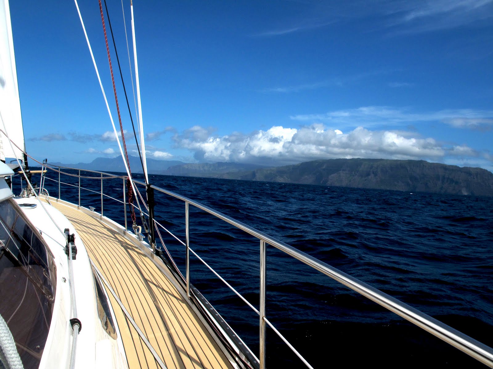
On day 18 (March 25), we had Hiva Oa in sight on the horizon.  As we got closer, the island was indeed an impressive sight, steep craggy volcanic peaks dipping dramatically into the sea.  Hiva Oa is the second largest island in the Marquesas archipelago – popularly mispronounced by WARC participants something along the lines of  “heave ‘er over…”  

Landfall Hiva Oa

Hiva Oa -- mountains meet the ocean

We approached the coast cautiously and crept into Baie Taahuku which has a breakwater protecting the main port wharf.  The finish line for this leg was crossed at 1422hrs Galapagos time, making for a total elapsed time of 18 days, 2 hours and 22 minutes for the 2980 nautical mile passage.  The harbor was already crowded with WARC and non-WARC boats many of whom had deployed stern anchors, making spacing at the anchorage quite restrictive.  We squeezed into the harbor on the west side of the bay near Voyageur and reported in to Rally Control.

Wednesday, March 3, 2010

Puerto Ayora

March 3, 2010 -- we will be here at Puerto Ayora, Santa Cruz Island in the Galapagos till March 7 when we head out for French Polynesia.  Our next destination is Hiva Oa in the Marquesas.  Meanwhile, we are spending our time provisioning, and checking out the boat for the 3000 mile passage.  The harbor at Puerto Ayora is an exposed bay with a constant Pacific swell.  If you like living in a rocking chair powered by a perpetual motion machine, then that's the spot for you.
The restaurants have seemingly similar offerings and anything that is not the usual breaded shrimp, fried fish or grilled chicken is likely to disappoint.  The purported Italian restaurant serves up stuff that is worse than the Olive Garden, the benchmark for bad Italian food in the US.  The pizza is soggy and tasteless, but after so many dishes of camarones apanada and pescado ala plancha, an escape to the bland doesn't seem so bad.
The town is busy and the harbor buzzes with activity.  The water taxis are downright dangerous and the drivers mostly unskilled at manouvering their craft.  Yesterday, a water taxi with a particularly rough driver gouged the gell coat on Skylark's hull.  Made me pretty mad but there's no way to have them make good the damage in a place like this.
The feel of the place is all at once exhilarating and depressing.  The islands have much to offer by way of flora and fauna but human migration, haphazard development and a central government mostly focused on the tourist dollar all go towards degrading their intrinsic appeal. A picture is worth a thousand words, so here are some photographs taken at random on my walks around Puerto Ayora:

The harbor at Puerto Ayora -- Skylark is the white boat in the center

Another view of the harbor

Fish stall, Puerto Ayora -- customers seem eager

gimme my fish....

Iguana visiting on the patio of the Red Mangrove Lodge restaurant

Local official's view of art -- iguana in concrete in the town's square

There won't be any posts for a while as we will be at sea with no internet connection.  The email system based on the single sideband radio will only be used for receiving weather forecasts and urgent matters. Will chat next when we reach the Marquesas.


Kicker Rock

While at San Cristobal Island, Ed and I did a boat trip to Kicker Rock, south of the island - one of the rare organized tours that we'd been on.  It is a magnificent rock structure split in two with a narrow channel.  There is an abundance of marine and bird species and the tour included snorkeling at Kicker Rock and a couple of other locations nearby.  Rays, sharks, turtles, sea lions and fish of many varieties cavorted with the humans in the water.  One bird that catches a lot of attention is the blue footed booby, whose feet are indeed a bright blue.  They are a Galapagos icon featured on the usual tourist junk such as t-shirts, hats, handbags, postcards and wood carvings.


One of the stops on this tour was a beach vaunted for its beauty but infested with horse flies waiting for anyone willing to go ashore.  Most of the tour group did and were duly bitten.

Kicker Rock ...from a distance


Channel at Kicker Rock

Blue footed boobies

Other side of Kicker Rock channel

Sunday, February 28, 2010

Tsunami at Galapagos

Tsunami (n., su-nah-mi) Japanese for "harbor wave", phenomenon caused by release of energy from earthquakes in the sea bed.

Left Puerto Baquerizo Morena, San Cristobal at 7 am, February 26 for Puerto Ayora on Santa Cruz, an island within the Archipelago de Colon, some 45 miles to the north west.  Heavy rain squalls on the way with winds from the south.  Sailed most of the way till the turn northwards to Santa Cruz Island, the wind was then from dead astern.  Motor sailed the last 8 miles to the rolling harbor at Puerto Ayora, arriving at 1300 hours local time.  The anchorage is crowded with small craft, some visiting yachts and of course, the smattering of WARC yachts.  We were required to have a harbor pilot lead us to an assigned spot where bow and stern anchors must be used to keep boats swinging at a consistent angle.  We were at anchor by 1330 hours with assistance from the pilot to set the stern anchor and had lunch on board.  The harbor is a jumble of anchored boats, small, poorly maintained local boats on moorings, with a lot of loose floating lines, some without floats attached.  We went ashore for a preliminary reconnaissance of the town – a somewhat run down main street (named after Charles Darwin, of course).

The first night at Puerto Ayora turned out to be rather eventful.  in the early evening, I went over to Voyageur (the MacKays yacht) and started up her genset for a couple of hours to charge batteries, returning later to check on anchor lines and to switch off the genset.  Everything normal.  Then, the big motor vessel “Treasure of Galapagos” anchored to our starboard with a rather slack stern anchor line began to swing on her moorings.  All night we watched her stern swing back and forth, perilously close to us as wind and currents changed.  A shout to one of the crew elicited a lazy look around and back he went to a deck chair with a magazine in hand.  Finally, around 2 am, after another call by Francois, he made some adjustments to the stern anchor line which improved the situation, but only marginally.  Not that it would have mattered…around 5 am, we got word from Christian on another WARC boat, the catamaran “1+1” that a major earth quake had occurred in Chile and that a tsunami warning was in force for the Galapagos. The tsunami was predicted to arrive at Puerto Ayora at around 0700 hours local time.  We discussed our options which were to put to sea or stay at anchor in the harbor to ride it out.  The predicted wave height was 1.2 meters which didn’t seem too bad.  A short time later however, the stay put option was no longer available -- port authorities ordered all boats out of the harbor as a precaution.  We had to leave.  Leaving was no simple matter as there were bow and stern anchors to handle in the dark (this time with no assistance from the harbor pilot) and the swells were greater than usual.  Many other boats had such difficulty freeing their stern anchors that they simply tied a float to the anchor line and dropped it in the water with the  intention to retrieve it on return.  We had our hands full even with three on board.  I worried about Voyageur whose owners the MacKays had left on a 5 day trip on a cruise ship.  After consulting with WARC, we felt Voyageur would be all right in the harbor, securely anchored as she was.  No help was going to be available as it was the wee hours and all other boat crews  were having enough troubles of their own breaking free from anchorage. There was no way to transfer crew to Voyageur under those conditions and we didn’t have the dinghy deployed due to use restrictions by the port.   We left the harbor as dawn began to break and made for deeper water beyond the 100 meter contour on the chart.  The sea state seemed quite normal out there.  We waited for word of the harbor’s re-opening which finally came around 1100 hours.  As boats made their way in, we decided we stay out and have lunch while the others sorted out their anchoring positions – no point joining in the jostle -- perhaps the good “parking spaces” would be gone by the time we returned but no matter.  When we finally got in, we found a spot that didn’t seem too bad.  This time, there was no assistance with the stern anchor and other boats were busy trying to find the anchors they’d abandoned when leaving.  Dinghies were literally buzzing all around us.  Many anchors and their lines went missing, others were tangled in a mess with other lines in the harbor.  We decided that it made sense to drop the bow anchor first, let out sufficient length of chain to bring the boat’s stern to the spot where we wanted the stern anchor located, drop it and then draw in the bow anchor while releasing the stern anchor line simultaneously to position the boat.  It worked well enough as we had space within which to move the boat.  The harbor seemed normal other than for a few other boats reporting rapid rising and falling of depth levels.  We didn’t observe much change in water levels, although the current seemed rather swift.  We stayed on board until we were comfortable with the anchoring position.  I went over to Voyageur to check her moorings and run the genset.  All was normal, evidence of David MacKay’s seamanlike anchoring techniques.

To celebrate the Tsunami, we had a crew dinner at a nice restaurant with an ice cream outlet on the side on Darwin street.  It was the first decent ice cream selection in the Galapagos with ice cream served in scoops rather than on a stick.  While waiting to return to Skylark at the water taxi dock, we observed water at extremely low levels with a swift outflowing current.  The current suddenly switched direction and began pouring into the dock area as if someone had flipped a switch.  It was a torrent and the water taxi driver had to wait a while before things settled and he could come alongside to pick us up.  Perhaps a mini Tsunami -- right before our unbelieving eyes.

That night, we spent time watching our anchor lines as the movement of water in the harbor seemed a little unsettled.  There were no problems but  again, low water seemed much lower than normal and the incoming tide brought strong currents.

It is Sunday, February 28 -- the harbor is still experiencing unusual conditions.  A spring tide this afternoon had water lapping at the edge of the main waterfront street (the moon was full).  Should be more settled by tomorrow, so the locals tell us. But all's well with Skylark and her crew.

Photos of Puerto Ayora in the next blog.

Wednesday, February 24, 2010

The Galapagos

Left The Puerto Lucia Yacht Club at  La Libertad at 1200 hours local on February 18.  It was the re-start for Leg 2 of the Rally.  (Leg 1 was St Lucia to the San Blas Islands followed by free cruising to Colon, Panama, Canal transit to Panama City and  to La Libertad).  After the start, we did essential maintenance like cleaning the seawater and water maker filters which we did not want to do in port at La Libertad due to the highly contaminated marina water and surface oil from natural seabed seepage and oil terminalling operations.  The normally white primary and secondary water maker filter elements had turned black from oil and other contaminants while in port at La Libertad.  The large power boat alongside also discharged a large black water holding tank before leaving on a weekend trip – logic that boggles the mind, since the accepted practice is to discharge holding tanks when out at sea.  Trailing the water maker filters on a line for about 25 miles got most of the solid debris out but the discoloration (to light gray) was unattractive.  We opted to install new filters but kept the “restored” filters for future use should spares run out.  The maintenance activity meant a leisurely pace which left us trailing most of the fleet.  The next day however, we shed earlier inertia and deployed the gennaker.  The rig required some tuning but after a while, we were able to make 6 to 7 knots under light wind conditions. Winds en route were generally light but quite consistent in direction – south westerly initially and turning southerly in the last half of the passage.  Intentionally or otherwise, Skylartk kept a routing that was different from the rest of the fleet – we didn’t see any other WARC boats till the day before the finish at San Cristobal.  Most boats had gone further south and encountered both light winds and rain squalls.  We’d hoped for rain to give Skylark a good fresh water rinse after the contaminated air of La Libertad which had left sooty residue on deck.  No such luck till the last night when we encountered some heavy rain.  Again, we thanked the ghost of Henri Amel for conceiving the helm station design on our boat – completely protected from the elements.

February 22, 0858 La Libertad time (1358 hours UTC) -- Arrived at Wreck Bay where Puerto Baquerizo Moreno is located on San Cristobal Island.  San Cristobal is the first of the Galapagos Islands or the Archipelago de Colon as it is known to the Ecuadorans.  Skylark was middle of pack in the WARC.  We could perhaps have done better but slowed down during the night so as not to approach an unfamiliar landfall in the dark.  Arrival formalities involved boarding and inspection by Immigration, Customs and agricultural control officials.  We were required to stay on board Skylark until clearance by the authorities at around 4 pm – a good 7 hours after dropping anchor.  After 4 days at sea, it was a frustrating experience.  Because we were initially advised that the visit by officials was likely prior to lunch, we did not get going with any on work on the boat. A case of  -- could have, would have, but didn’t resulting in a mostly wasted day. 

Anchorage at Wreck Bay, Puerto Baquerizo Morena

Puerto Baquerizo Morena, provincial capital of Galapagos

The weather at anchor on the first night was dreadful – heavy rain, uncomfortable swells.  I woke up at about 3 in the morning and went up to the cockpit to check on things.  I thought Francois had chosen to sleep on the port side cockpit seat and in the semi-darkness, tapped him on the shoulder.  “Francois” turned out to be a very large sea lion that had clambered aboard and settled down to sleep on the cushioned seat.  It reared its head and barked loudly.  Startled, I retreated below to the saloon and woke Ed up.  He stuck his head out of the main hatch and barked loudly at the sea lion who was equally startled and quickly slid off the transom back into the water.  The next morning, Francois was not amused at being mistaken for a sea lion.


Sea lions at the Puerto Baquerizo Morena waterfront

Tuesday, February 23 -- Ed and I hired a taxi to take us to 3 places recommended by the local Tourism Office.  The first was the Galapaguera Cerro Colorado, 12 hectares of forest containing a breeding center for the giant tortises.  It was a rainy day but the visit was well worth the effort as pictures below show.


Ed and the taxi driver who drove us around

The second site was the beautiful beach at Puerto Chino which was followed by a visit to the Laguna El Junco.  The Junco is a fresh water lagoon formed in the crater of an inactive volcano.  The impermeable rock and rain water resulted in the lagoon which today continues to be sustained by the same conditions.

Puerto Chino
The Laguna El Junco - barely visible in the rain and mist